Showing posts with label ArcGIS. Show all posts

Tuesday, July 13, 2021

AMOS Goes Camping

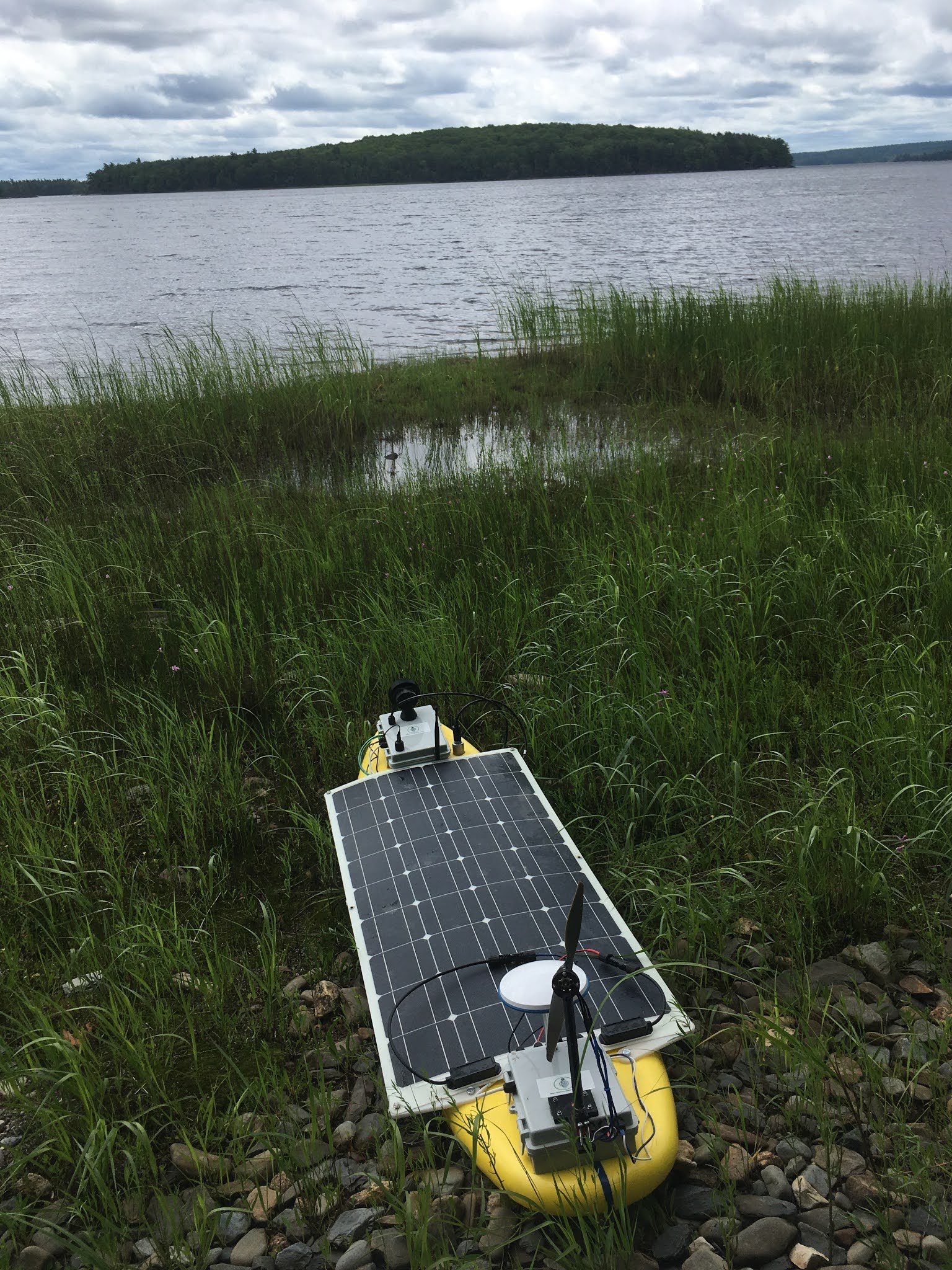
This past weekend I went with my daughter to her triathlon training camp at Kejimkujik National Park in Nova Scotia. We purchased a campsite for two nights and brought the tent, her bike and other triathlon-related equipment, a kayak, and of course AMOS! While Kirsten practiced swimming, biking, and running, I figured I could test out AMOS and follow around in the kayak.

The weather on Friday turned out to be awful though. Tropical storm "Elsa" passed through the area late in the day with high gusting winds and buckets of rain. The fly on our camping tent kept nothing dry, as rain was easily blown underneath, so that by Friday evening, it was basically raining INSIDE the tent too. We  decided to put AMOS, the bike, and most of the other equipment in the tent, and ended up spending the night in the van instead. 

Fortunately the weather on Saturday was much better, and by noon it turned into a sunny hot day. While Kirsten was training around Merrimakedge Beach, I mostly kayaked and observed AMOS as it followed a pre-programmed sampling course. Unfortunately I had forgotten to bring a necessary cable for the depth sensor, but did manage to get some good conductivity and temperature data over a few hours:


 Over the last couple of weeks some progress has been made on the Android app for viewing AMOS and phone / tablet positions on an Esri / ArcGIS map: 


At present you can see the position of AMOS (yellow boat outline), and the position of the phone / tablet holder (white stick figure), but there is no data visible on the map yet, just some diagnostic information below the map.


Tuesday, April 14, 2020

Backyard Puddle Test

We had a fair amount of rain yesterday and last night, which combined with the leftover snow from winter to make a giant puddle in the corner of our backyard. Although it didn't really provide quite enough room for AMOS to get going, I felt the need to try out the boat in  some actual water for the first time this year:


The boat quickly became fetched up on an alder and needed to be rescued by wading part-way into the puddle and reaching for it with a hockey stick. This version of AMOS (AMOS-Catamaran or AMOS-Cat for short) seemed to have about the same draught as the surfboard version, i.e. about one cm, maybe a bit more at the back end due to the weight of the battery.

A lot of work was done this past week on the new version of the PC BoatCaptain software for controlling AMOS and viewing info on ArcGIS maps. I was able to get the boat route, safety locations, and photographic locations all to appear properly in the application and in the saved web maps, and was also able to load those saved web maps into the application. For some reason though, I could only view multi-colored data points from within the application; when I tried to save a map with multi-colored data points in it to the web, all of the points in the web map became the same color. I suspect it's just a limitation of the SDK that I'm using, or the web service that does the saving of the map, but I asked a question on a relevant forum to see if anyone else knew.

For this week I want to focus more on the new BoatCaptain software for controlling and interacting with AMOS. The weather is quickly warming up and it will soon be time to start collecting more test data!

Tuesday, April 7, 2020

Happy Birthday to That Hobo Who Works in Our Backyard Playhouse

There is a bit of a running family joke that there is a hobo squatting in our daughter's playhouse. I have been using the playhouse as a work space lately in the afternoons when the sun is out. It is nice and quiet there, without any of the distractions that are typical within a 5-person home. Today was my birthday, so unbeknownst to me, Kelly went out in the morning to decorate it before my afternoon work session:


Much of this past week has been spent re-writing the graphics code for the new version of the desktop BoatCaptain software. I eventually figured out the methodology required for creating graphics in the application's map that will also show up the same way in a version of the map stored on the web. Saving simple symbols was fairly straightforward, but getting custom image icons (using the "PictureMarkerSymbol" .Net ArcGIS class) to save properly in the version stored on the web took me hours to figure out. It turns out that you need to explicitly define the dimensions of the PictureMarkerSymbol, otherwise it won't display at all on the web.

For example:
    
      PictureMarkerSymbol crossMarker = new PictureMarkerSymbol(new Uri(sImagePath));
      crossMarker.Height = 20;
      crossMarker.Width = 20;
      
Kelly happened to notice a Facebook post about a boy that had 3D-printed a number of "ear guards" that help to ease some of the pressure on the ears of hospital workers wearing masks with elastic straps that hook behind the ears. The model of the part can be found here: https://www.thingiverse.com/thing:4249113. She wondered if I could make any on my printer, and I wasn't sure; I usually have trouble printing things with small details over a large surface area. After a bunch of tweaks and a few failed prints I was able to find some settings I had never tried before that worked really well. I made 3, which she gave to a nurse she knows, so we'll see if they're actually useful or not. The new 3D printing configuration also worked really well for this pH probe holder that I just made today:


Tuesday, March 3, 2020

Meet Jata, Employee #1!

Thanks to some funding support from Venture For Canada, In Nature Robotics is pleased to announce that Jata MacCabe will be the company's first ever employee, working as a sales and marketing intern for the May to September summer term of this year. Jata is a multi-scholarship student and is currently completing her 3rd year of Computer Science at the University of New Brunswick, specializing in information systems. She has also completed a number of business and marketing courses and has extensive experience building and promoting digital communication platforms for small businesses, which should serve her well in her upcoming work term.


In less exciting news, I got the pontoons for the Cat-AMOS nicely sanded to a smooth finish, and visited a metal fabricator to inquire about possibly getting them encased in aluminum. The pontoons as built could not be encased in aluminum, since any welding process would certainly melt them, but it would be possible to make a twin-hull aluminum Catamaran that could be filled with some sort of spray foam, for buoyancy in the event of a leak or damage. The only problem is that any sort of aluminum structure of the size required to hold the solar panel and electronics boxes would weigh at least 35 lbs, probably more. The current surfboard design is only about 29 lbs, with the battery, electronics boxes, and everything included. So I guess I'll be sticking with a fiberglass shell for the foam pontoons. Hopefully I'll take better care around the edges this time to make sure that everything is nice and smooth without any fiberglass splinters. 

I also got more done on the ArcGIS-based mapping software for viewing diagnostic files recorded from AMOS. The following video is an example of the interface for viewing where the boat traveled, and what its internal temperature, voltage, and heading was at any given point of time.


Tuesday, February 11, 2020

Better Data For 2020

There are at least a couple of ways that AMOS could be updated to provide users with improved water quality data. One would be to add some industrial water quality probes that are capable of collecting calibrated data for a wide variety of parameters. Another would be to improve the data presentation software that is used to represent the data that AMOS collects. Some progress was made on both these fronts this week.

In order to continue updating the map-based data presentation software that AMOS uses, I first needed to get a new Esri ArcGIS license, as the free one I was using had expired. Luckily Esri offers a free account with some limitations for developers, which turned out to be good enough for my purposes. Using some temperature data that AMOS had collected last October, I was able to generate this nice color coded water temperature plot:


I think the color coded points on the data map look better than having blobs of varying sizes on the map. With color coding, you can also imagine a feature where data could be interpolated in the locations between sampling points by taking a weighted average of the surrounding points.

I have also been asking around and getting quotes from 4 of the major water quality probe manufacturers. Basically I would like to have a multi-sonde that comes with probes for temperature, turbidity, pH, dissolved oxygen, and blue-green algae. All of the manufacturers seem to support communications interfaces with 3rd party dataloggers, typically using RS-232 or RS-485. So far I have gotten prices from a couple of the manufacturers, and am waiting for quotes from the other two. The sensors are not cheap, so I want to do my research and make sure that the ones I decide on will be able to provide AMOS with reliable, accurate measurements.

In preparation for an experimental catamaran version of AMOS, I found a hot-wire cutting device on Amazon that looks like it should be suitable for cutting through 2" sheets of pink insulation:

Hopefully it will help me to make more even cuts in the foam with fewer gouges and less time spent sanding.

Tuesday, December 17, 2019

Starting to Get Real

A few small things happened this week that helped to reinforce my belief that AMOS can be a viable product.

On Friday, some market research reports that I had requested through Venn Innovation and MaRS Knowledge & Insights came in. In total there were 9 different reports mostly dealing with water monitoring technology. I've only read 2 of the reports so far, but it is clear that the World's water supply is increasingly being threatened by pollution, global warming, changes in weather, and other factors, and that there is a growing demand for reliable, effective monitoring technology for making sure that our water is safe. It seems clear to me that automated robotic water sampling will be needed in the future; hopefully AMOS can be part of that.

On the software side of things, with the help of the ArcGIS API, I came up with a pretty simple interface for planning a route for AMOS:

You basically just left-click the waypoints in the sequence that you want AMOS to follow, or right-click on a point to remove it. Then click the 'Save' button to save the route to a text file for upload to AMOS. It sure beats entering GPS coordinates by hand. I've made mistakes that have resulted in some serious head scratching when AMOS started to head off to the latitude and longitude of my typo.

In Nature Robotics now has an official presence on Twitter: @nature_robotics (https://twitter.com/nature_robotics). It was encouraging to see how many people there are on Twitter that are actively engaged in water monitoring and research about water. Many thousands to be sure. In Nature Robotics now follows a little over 200 of them, and will be following more gradually.

Over the course of the last 21 months that I've spent working on AMOS-related things, some spare parts have managed to accumulate around our basement. My part-time employer (Measurand Inc.) is having a Secret Santa gift exchange this year, with the rule being that the gift must be hand-made or less than $15 in price. Since I drew the Occupational Health and Safety Coordinator, I thought I could make some use of a spare humidity sensor and Arduino to help him make sure things aren't too hot, cold, humid, or dry in the workplace: